Berghaus "Mattajoch", Nenzing-Alpe Gamp 1564 m

Mountain Bike Circuit from Nenzing via Beschling to Alpe Gamp

This challenging mountain bike circuit starts near Nenzing railway station and climbs via Beschling to Alpe Gamp. Long and at times steep climbs, varied surfaces and technically demanding sections require an excellent level of fitness and advanced bike-handling skills.

The route reaches its highest point at Alpe Gamp, at around 1,560 metres. In clear weather, the panoramic views extend across the Walgau and the Rhine Valley as far as Lake Constance and the Arlberg. The varied descent follows a different route through woodland and alpine pastureland back to Nenzing.

Details

Difficultydifficult
Highest point1560 m
Best time of year
JanFebMarAprMayJun
JulAugSepOctNovDec
Overview

This challenging mountain bike circuit starts near Nenzing railway station and climbs via Beschling to Alpe Gamp. Long and at times steep climbs, varied surfaces and technically demanding sections require an excellent level of fitness and advanced bike-handling skills.

The route reaches its highest point at Alpe Gamp, at around 1,560 metres. In clear weather, the panoramic views extend across the Walgau and the Rhine Valley as far as Lake Constance and the Arlberg. The varied descent follows a different route through woodland and alpine pastureland back to Nenzing.

Route description

The circuit starts near Nenzing railway station. From there, it initially leads through the village and continues along a largely flat section to Beschling. This first part provides an opportunity to warm up before the long climb.

In Beschling, the route passes through the village and by Villinger Kirchlein. The climb towards Alpe Gamp then begins. The route initially follows surfaced tracks before continuing uphill on an increasing number of forest and gravel tracks.

At Beschlinger Berg, the route quickly gains height. Sections of woodland alternate with open ground, regularly revealing views across the Walgau and the surrounding mountain ranges. Several hairpin bends and steep pitches lead onwards towards Brändlekopf. On particularly steep or rough sections, it may be necessary to push the mountain bike for a short distance.

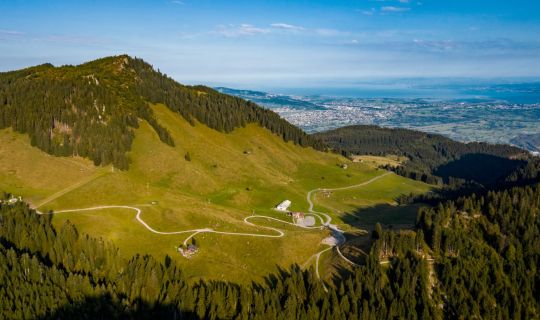
Higher up, the woodland gradually gives way to alpine pastureland. The route continues to Alpe Gamp, where it reaches its highest point at around 1,560 metres. In good visibility, an extensive panorama opens up across the Walgau and the Rhine Valley as far as Lake Constance and the Arlberg.

After a rest, the descent begins via a different route. It follows partly steep forest and gravel tracks back towards Beschling. Loose stones, eroded sections and tight bends require controlled riding and a confident braking technique.

From Beschling, the route returns to Nenzing along quieter roads and tracks. The challenging circuit ends near the railway station.

Getting there

Nenzing railway station is the recommended starting point. The circuit starts and ends close to the station.

By public transport

Bus stop at the start and finish: Nenzing Bahnhof

Railway station at the start and finish: Nenzing Bahnhof

Nenzing Bahnhof is served directly by S-Bahn line S1 and can be reached from Bregenz, Dornbirn, Feldkirch and Bludenz, among other places. Various regional bus services also stop at Nenzing Bahnhof. Please check the arrangements for carriage of bicycles and the availability of spaces before travelling.

Journey planner: vmobil.at

By car

Take the A14 to the Nenzing/Bludesch exit. Continue along the motorway feeder road and the main road towards Nenzing. Bahnhofstraße leads to Nenzing railway station. A valid motorway vignette is required to travel on the A14.

Parking

Parking is available at Ramschwagsaal:

Ramschwagplatz 1

6710 Nenzing

The municipality currently designates the parking spaces immediately around Ramschwagsaal as free of charge. Availability may be limited during events. Please follow the signs and check the current local regulations on site.

Equipment

Good equipment is recommended for this cycle tour: a well-maintained mountain bike with grippy tyres and reliable brakes, a cycle helmet, a cycling backpack if required, comfortable shoes or cycling shoes, cycling gloves, clothing suitable for the weather, sun and rain protection, a bicycle pump, spare inner tube or repair kit, bicycle tools, food and sufficient drinking water, a first-aid kit, a mobile phone and a charged power bank.

A sufficient battery reserve is required when riding an e-mountain bike because of the long climb.

Safety information

This tour is suitable only for experienced mountain bikers with an excellent level of fitness and confident bike-handling skills. Long and at times steep climbs, together with rough and loose surfaces, may require short sections where the bike has to be pushed.

During the descent, expect gravel, eroded sections, tight bends and extended steep sections. Always adapt your speed to the surface, visibility and your personal ability.

After rain, forest tracks, roots and stones may be slippery. Do not set out in thunderstorms, fog, heavy rain or during an early onset of winter. If conditions deteriorate, turn back in good time. Snowfields may remain at higher elevations into early summer.

The route is shared in places with walkers and agricultural and forestry vehicles. Ride considerately, maintain sufficient distance and observe any trail closures. When livestock are grazing, close gates after passing through and keep your distance from the animals.

The tour is undertaken at your own risk. Before setting out, check the weather forecast, trail conditions and any possible closures.

EMERGENCY NUMBERS:

112 European emergency number

140 Mountain rescue

144 Ambulance service

Additional information

Refreshments and rest stops:

Berghaus Mattajoch, near Alpe Gamp, offers somewhere to stop for refreshments. It operates seasonally. Check opening times, closing days and any reservation requirements before the tour.

The open areas around Alpe Gamp are suitable places to stop and rest. Please keep working agricultural areas clear and take all litter with you.

Panoramic views:

Alpe Gamp lies high above the Walgau. In clear weather, the views extend from Lake Constance across the Rhine Valley and the surrounding mountain ranges to the Arlberg.

Time of day:

An early start is recommended. This leaves sufficient time for the long climb, a break at Alpe Gamp and the technically demanding descent. In summer, aim to complete the lower-lying, sunny sections before the hottest part of the day.

Suitability:

The tour is not wheelchair-accessible. Due to the metres of ascent, steep sections and technical demands, it is not suitable for families with young children or inexperienced cyclists. Advanced bike-handling skills and experience in mountain terrain are also required when riding an e-mountain bike.

Shortening the route:

Anyone wishing to end the climb early should return to Beschling along the same route. In the upper alpine pastureland, there are only a few straightforward ways to shorten the tour substantially.

Best time of year:

June to October, depending on snow conditions, weather and trail conditions. After heavy rainfall or an early onset of winter, some sections may be impassable or difficult to ride.

Tour-Quickfacts
Difficulty
difficult
Distance
22,9 km
Duration
04:35h
Ascent
1050m
Descent
1050m